Do we know how many trees grow in our city? Where is the highest tree in our neighbourhood and what is its height? What is the crown area of the trees growing on our property? The answer is the Regional Tree Crown Map available HERE
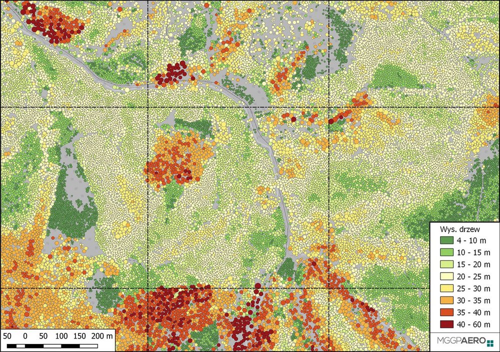
The Regional Tree Crown Map is a unique solution on the Polish market, which has been developed by the Małopolska company MGGP Aero from Tarnów. The Tree Crown Map has been created as a result of work of an interdisciplinary team of specialists and the research potential of the company. It is a response to the contemporary needs related to the management of high greenery. The Regional Tree Crown Map contains the results of the inventory of trees growing throughout Poland. It presents tree crowns, the height of which is more than 4 m, and the area of their crowns greater than 9 m2.
Information about every tree provided by the website is: location of the tree crown, height of the tree, area of the tree crown and its volume, tree species, tree health, trunk location, diameter-at-breast height (DBH).
How was the map developed?
The product was developed based on the data obtained by airborne laser scanning, which constitutes the resources of the Head Office of Geodesy and Cartography, which on 31 July 2020, following other European countries, was released and transferred to the public free of charge in accordance with the INSPIRE directive. The point cloud obtained over the years 2011-2020 was analysed by airborne laser scanning (ALS). Machine Learning methods, developed by MGGP Aero in the R&D department, were used to develop the product.
Obtaining information about trees for the entire country was possible thanks to the use of remote sensing analysis methods, which means that the inventory was performed remotely, without the need to perform measurements directly in the field. The source of information about the trees in this case was data obtained from the aerial ceiling. A special laser, the so-called ALS (Airborne Laser System), which measured the height and area of tree crowns from a height of about 1 km was installed on board of a manned aircraft. The inventory of all trees in Poland required over 1,523,995 million laser measurements. From the air, over 3.3 billion crowns of trees were inventoried, seen from above, with a total area of 9,669,476.2 ha, which is 30.92% of the country's area.
Who is the Tree Map for?
The idea that guided the authors when creating this pioneering solution was to provide basic information about trees in Poland in an accessible way that does not require specialist knowledge and skills. Thanks to this, the Regional Tree Crown Map can be used by both hobbyists and professionals, e.g., as part of supporting the processes of Poland's adaptation to climate change.
The information which has been obtained and presented on the website is of great value to all users, but it will be particularly useful to green area managers of local authorities, infrastructure managers and nature conservation services.
The highest tree in Poland grows in the Sudety Mountains.
So far, the title of the highest tree in Poland belonged to the Douglas fir (pseudotsuga menziesii) growing in the Ujsoły Forest District in the Beskid Żywiecki Mountains. According to the measurements taken in 2020 it reached the height of 58.20 m. While working on the data from the Regional Tree Map (currently available on mapadrzew.com), Agnieszka Ptak from the MGGP Aero team discovered trees in the Sudety Mountains that already in 2011 were more than 56 metres high. Thus, there was a suspicion that these trees may now be taller than the record-breaking Douglas fir from the Beskid Żywiecki Mountains.
The discovery was preceded by weeks of analyses of airborne laser scanning data made available for the whole country by the Head Office of Geodesy and Cartography. As a result of these analyses, the region of the Bardzkie Mountains was selected as the area where the potentially tallest tree in the country can be found. However, the final verification of the assumption required height measurements performed directly in the field.
As a result of the measurement, it turned out that the Douglas fir measuring 59.40 m, which is located in the Bardzkie Mountains, is the highest tree in Poland.
Source: MGGP Aero Sp. z o.o.,
Edit: Promotion Centre, UL